Forecast Discussion Update 9/30 4:36 PM

The colder air was fully entrenched across Alabama last night. The official low in Tuscaloosa was 49 degrees. Our friends in the capital city of Montgomery also felt upper 40s. Mobile was just shy of that mark at 52 degrees. Tonight will be another chilly one but it won’t be quite as cold. In fact, a southerly flow will be developing over the next 24 hours and this will set the stage for increasing moisture. Highs tomorrow will be near 80 degrees, with increasing clouds. The clouds will continue to build in tomorrow night and there will be a band of rain and thunderstorms approaching after midnight.

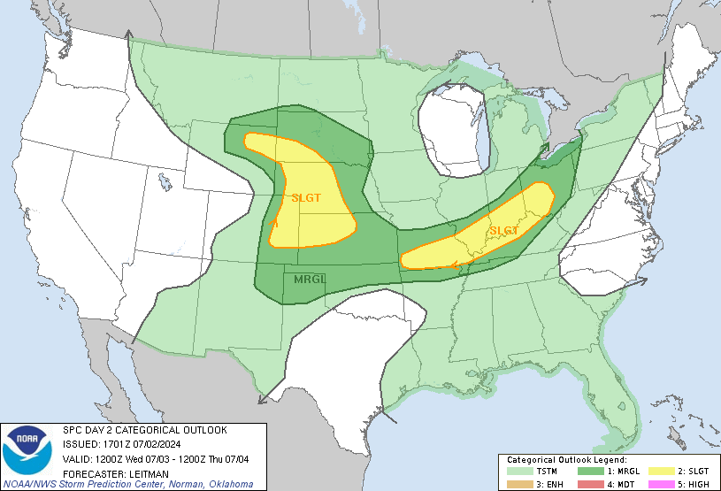
A low pressure system is materializing over the Nation’s midsection. This storm system will head east quickly, pulling a cold front in our direction. Some strong to severe thunderstorms will be possible over the Arklatex region tomorrow. This activity will weaken a bit tomorrow night. By Friday morning we will wake up to a gusty south wind, with showers and thunderstorms likely. The good thing is that the severe weather threat will be lower. Look for the rain to head east, with some afternoon sunshine on Friday. A dry flow will take over, with more sunshine this weekend. Highs for Saturday and Sunday will reach the middle 70s, with lows in the cold 40s.

A moist southwest flow aloft will take over by Monday. We will have increasing clouds, with a chance for a shower Monday night. We will have more clouds than sun on Tuesday and Wednesday, with the chance for a few showers. Highs will remain in the 70s. This setup may remain in place through the end of next week. Be sure to join us tonight for more details!

(IMAGE: SPC Slight Risk Severe Weather Outlook For Tomorrow)

Follow Me on TWITTER!

Wes Wyatt
Chief Meteorologist

Football Gameday Forecast – Lexington, KY

If you’re heading up to Lexington, KY  to cheer on the Crimpson Tide this weekend, expect some chilly weather at Commonwealth Stadium.  On Friday there will be a good chance of rain and storms in Lexington, with highs in the upper 60s. Saturday will be drier, with some colder air settling in.  Temperatures will be in the 50s at the 11:21 AM kickoff time. You can expect a 7 – 14 mph northwest wind.

You will certainly want to take a light jacket for the morning, although a jacket won’t be necessary late in the game. Morning clouds will give way to sunshine, with afternoon highs in the 60s. The weekend should be a nice one with typical fall like conditions. If you catch some fall foliage as you travel northward be sure to grab some pictures. Have a safe trip to the bluegrass state and Roll Tide!

Chase Higginbotham
WVUA Weather

Forecast Discussion Update 9/29 4:10 PM

Our first true taste of fall is here! We started off the day with some neighborhoods in the 40s. The city of Pinson was one of the colder spots, with a morning lows of 46 degrees. The official low in Tuscaloosa was 50 degrees. The sky will be clear tonight and with light winds, lows will be dropping into the middle 40s area-wide. After a cold start tomorrow, get set for another enjoyable afternoon. We will have a sunny sky, with highs in the upper 70s. A warmer southerly flow will take over on Thursday, with some clouds arriving late. Highs on Thursday will reach the low 80s.

A low pressure system and associated cold front will move into the nation’s midsection on Thursday. This storm system will bring the threat of severe weather to the Plains states. A band of rain and storms will track into western Mississippi Thursday evening. We may have some showers locally, with our greatest chance for rain on Friday. Thunderstorms will also be possible locally, especially in areas to our south. The cold front will move through with drier air arriving on Saturday.

We should enjoy dry conditions through much of the weekend, although some clouds will linger. In the long term, a moist southwest flow will return early next week. Energy riding through this flow will bring a return chance for showers next Tuesday and Wednesday. Be sure to join us tonight for more details!

(Graphic: From SPC-Slight Risk Outlook for Severe Weather)

Follow Me on TWITTER!

Wes Wyatt
Chief Meteorologist

“Tsunami In The Pacific”

A large earthquake struck about 120 miles southwest of American Samoa around noon(Local Time). This caused a tsunami that struck the island of Pago Pago. This was an interesting email that was forwarded to my email box. One of our engineers has a friend who owns a radio station in Pago Pago.

He writes:

A little over 2 hours ago, an 8.3-magnitude earthquake (originally reported to be a 7.9) struck about 120 miles southwest of American Samoa. An hour and a half later, a 20-30 foot tsunami hit Pago Pago. I was able to speak with Joey briefly and he says things are “really, really bad.” Whole buildings in the Pago Pago Harbor area have been destroyed. Many people may have died, but nothing confirmed yet. It happened just after 7am local time, so the school buses were on the road.

We were able to air the tsunami warning several times before it hit. Power went off shortly thereafter. The generator for the studio is in the parking lot, which is under 15 feet of water, so we’re now off air until we figure out an alternate power source.

Our studio facility is on the second floor of the building, so we’re dry and intact, just no power.

Our staff is all accounted for. Many of our automobiles are not.

I’m in Mississippi this week. More as I know it.

Wes Wyatt
Chief Meteorologist

Forecast Discussion Update 9/28 3:48 PM

A few more clouds made there way into West Alabama today as a secondary cold front entered the area. A few isolated showers developed over our far southern counties and this activity will be shifting southward. A dry northwesterly flow has taken over and it is feeling very nice for a change. Tonight is going to be very chilly, with lows near 50 degrees. In fact, over the next few nights we will have some middle to upper 40s for low temperatures. So it’s probably time to start breaking out some of that cold weather attire.

A strong surface high will be positioned near Tulsa, OK tomorrow. This will keep a dry northerly flow in place through Thursday. We will enjoy a bright sky each day, with lows in the 40s. By late Thursday a southerly flow will begin as a front approaches Alabama. We will have increasing clouds on Friday, with a good chance of rain late. The wet weather should depart early on Saturday, with some lingering clouds. I’m expecting milder temperature to linger into Sunday and Monday with a mix of clouds and sun.

Follow Me on TWITTER!

Wes Wyatt
Chief Meteorologist

Weather Picture

photoI want to thank Andy Norris for sending us this picture of a shelf cloud approaching Northport near Mitt Lary Rd. yesterday. There was a strong thunderstorm that moved through northern Tuscaloosa County around lunchtime. Thankfully, the rain moved out just in time for Alabama’s big game.

Sunday Afternoon Weather Discussion – 1:30 PM

A good Sunday to you! Today’s weather is polar opposite from what we dealt with yesterday. The heavy rain moved out early yesterday afternoon, which has now left much of Alabama underneath a nice setup. The cold front moved through around midnight lastnight, which has brought the first round of nice weather. A second cold front is on the way, and will move in here Monday afternoon. With limited moisture, we aren’t expecting any rain with this. At the most, we will see a few more clouds ahead of the front. Temperatures behind the front will be much cooler.

Highs today will reach the middle 80s. As humidity values have dropped off, it doesn’t feel bad at all. Temperatures tonight will reach the lower 60s, which is average for this time of the year. On Monday, temperatures will return into the middle 80s, with a lot of sun. Cooler air moves in on Tuesday; highs will stay in the 70s all day, with a high near 78 degrees. Temperatures will reach the upper 40s on Wednesday and Thursday morning. That’s going to make conditions feel much like fall. Temperatures slowly rebound into the lower 80s by Thursday and Friday, with lows warming into the 50s on Friday and Saturday morning.

Models have become a little more consistent in bringing another cold front in here on Friday or Saturday. This will enhance our rain chances for the start of the weekend. As of now, I’m sticking with a 30% chance of rain, but that rain chance may have to be bumped up over the next few days. Some data suggest some really chilly weather moves in behind the front. We’ll keep a close eye on that, but it’s too far out to make a big change in our forecast at this point. Be sure to join us tonight at 10 PM for the latest on your news, weather and sports on WVUA-TV.

Follow Me on TWITTER!

Have a great day!

Richard Scott

Saturday Afternoon Weather Discussion… Rain Moves Out… 2:45 PM

We’ve dealt with a rough start to our weekend, with a batch of heavy rain working across the state. The rain has moved out just in time for the Alabama football game in Tuscaloosa. We could still see a shower or two this afternoon, but the heavy rain is over. Our friends in eastern Alabama will continue to see heavy rain through the rest of the afternoon. As a cold front moves through the state this evening, we will finally see a change in our overall weather pattern. Lower humidity values will flow into the state tonight, which will make our weather feel great!

On Sunday, a good supply of sunshine is expected; temperatures will remain in the middle 80s for highs. Other than a warm afternoon, it’s going to feel a little more like fall. Another cold front is on the way for Monday; due to low moisture values, we won’t have any rain to deal with. As the front moves through Monday afternoon, we’ll see a few more clouds, but that will be about it. Our data continues to bring cooler air in on Tuesday and Wednesday. High temperatures will top out near 80 degrees on both Tuesday and Wednesday; expect mostly sunny skies both days. With low humidity, it will feel a lot like fall through Thursday. Low will bottom off in the lower to middle 50s Tuesday, Wednesday and Thursday mornings. Things become a little more unpredictable by next weekend. Some data suggest that another cold front will move through on Saturday; we’ll keep an eye on this as we get closer.

Tropical Depression Eight has formed in the central Atlantic. There are no worries with this system, as it is expected to turn out to sea. Be sure to join us tonight on WVUA-TV news at 10.

Follow Me on TWITTER!
Have a great day!
Richard Scott

Rain Is Moving Out Of Tuscaloosa! – 2 PM

Our afternoon has turned soggy across much of west and central Alabama, with heavy rain at times. The good news for the tailgaters on the University of Alabama campus, rain is moving out. Looking at the latest radar trends, the rain should be over by 2:15 PM, which will be just in time for the game. So far, there is no more rain developing to our west, so our rain chance is going down for the rest of the day. The rain will shift into east Alabama, where rainfall will last for much of the day. Other than a left-over shower or two, our rain is moving out of west Alabama. I’ll have a fresh weather discussion on here in about an hour.


WVUA-TV’s Richard Scott

Flash Flood Reports in Walker County – 12:05 PM

We are getting flash flooding reports out of Walker County. Several roads are reported closed in Cordova and Parrish due to flash flooding. Do not drive through flooded roadways! It doesn’t take much running water to sweep a vehicle off of a highway, so don’t take that chance. There is a flash flood warning for Walker County until 2:15 PM.

WVUA-TV’s Richard Scott