Warm Days For Now… Severe Storms Possible Thursday Tuesday PM Forecast Update #alwx @wvua23

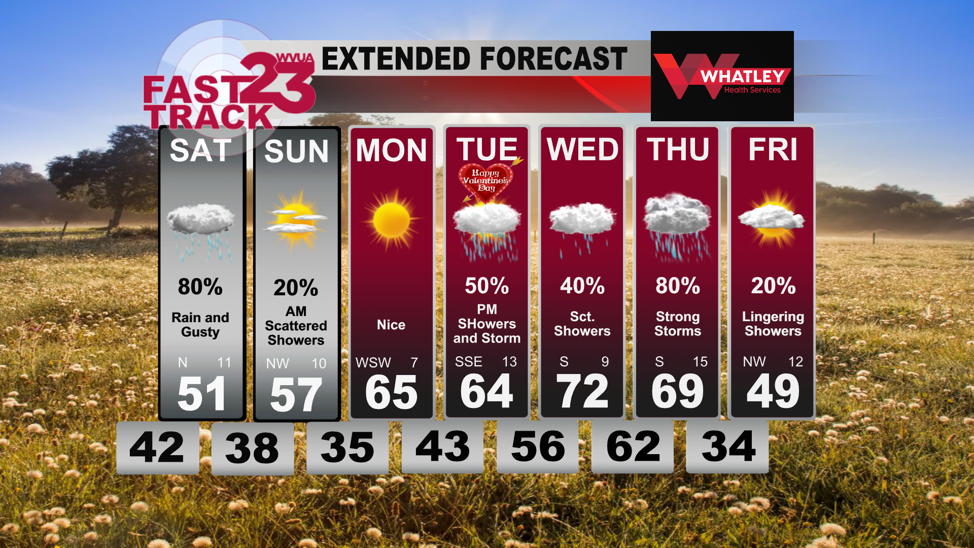
Good Tuesday afternoon! Our local weather was much warmer today, with many areas reaching the lower 70s this afternoon. Temperatures will slowly fall into the lower 60s overnight, under a mostly cloudy sky. A few showers will become possible overnight, as a weak surface front stalls across the region. A light south breeze will continue overnight.

Wednesday will include a mostly cloudy sky, with the risk of a few passing showers and maybe a rumble of thunder. Severe weather is not expected on Wednesday.

Thursday, a surface cold front will approach from the west, with a good chance of rain and storms. A few storms could become severe on Thursday, especially during the afternoon hours. Damaging winds, hail and a few tornadoes will be possible.

Cooler air will move in on Friday, with highs struggling to reach the lower 50s.

As a reminder, we go on TV at WVUA23 non-stop during a tornado warning. We also stream non-stop on Facebook live too, search WVUA23. This is a good time to go over your severe weather safety plan and be ready to take action if needed.

Join us live on WVUA23 weekdays at 5, 6 and 10:00 P.M. and weekends at 10PM for the very latest on your news, weather and sports.

Richard Scott
WVUA Chief Meteorologist
rscott@wvua23.com
Twitter: RichardWVUA23
Facebook: WVUA23RichardScott
Youtube: https://www.youtube.com/c/RichardScottWeather

Warm Days Ahead… Severe Storms Possible Thursday… Monday PM Forecast Update #alwx @wvua23

Good Monday afternoon! Our local weather will remain warm over the next few with, with daytime highs warming into the 70s. It will turn cool tonight, with a low in the lower 40s. Skies will become partly cloudy overnight.

For Valentine’s Day, expect a high in the lower 70s. Clouds will increase during the day, with a breezy southeast wind developing. Winds could gust over 20mph at times on Tuesday and Wednesday. A few showers will be possible Tuesday night and Wednesday.

We’re looking at a severe weather risk on Thursday. Not much change regarding the severe weather threat. At this time, the main window appears 8am – 8pm, but I’ll narrow that down this week. All modes of severe will be possible, including a few tornadoes and damaging winds.

It is possible the better support passes north of the area, which could limit the risk some. That being said, there is a risk and we’ll need to monitor trends.

As a reminder, we go on TV at WVUA23 non-stop during a tornado warning. We also stream non-stop on Facebook live too, search WVUA23. This is a good time to go over your severe weather safety plan and be ready to take action if needed.

Join us live on WVUA23 weekdays at 5, 6 and 10:00 P.M. and weekends at 10PM for the very latest on your news, weather and sports.

Richard Scott
WVUA Chief Meteorologist
rscott@wvua23.com
Twitter: RichardWVUA23
Facebook: WVUA23RichardScott
Youtube: https://www.youtube.com/c/RichardScottWeather

Beautiful Start to the Week… Storms Thursday… Sunday PM Forecast Update #alwx @wvua23

Good Sunday to you! It has been a beautiful day here locally with plenty of sunshine and temperatures topping out around 60 degrees. Temperatures will dip down to right around the freezing mark tonight. If you are staying out for the big game, make sure to bring a jacket with you.

Dry conditions will stick around for Monday and Tuesday. Temperatures warm to the low 70s by Tuesday. The models have scaled back on the rain chances for Valentine’s Day. Some of us may see a sprinkle later on in the evening when you’re coming back from date-night around 9pm. It won’t be much of anything to effect your love-day plans.

The main wet weather comes in mid-week for Wednesday and Thursday. Temperatures will be quite warm in the low 70s for then. The Storm Prediction Center has already flagged Thursday for potential strong-severe storms. The models are still unsure on exactly when these storms will move through on Thursday. What we do know is that this system looks to move quickly across the state. This is a ways out so we will keep you updated on Thursday’s details as we get closer.

What you can do now is prepare for Thursday. This means to make sure you have batteries in your weather radio and have a severe weather safety plan in place. These storms are associated with a strong cold front that will drop our temperatures significantly for Friday and overnight into Saturday.

Join us live on WVUA23 weekdays at 5, 6 and 10:00 P.M. and weekends at 10PM for the very latest on your news, weather and sports.

Megan Hanna
WVUA Weekend Meteorologist
Socials: @meganhanna_wx

Widespread Rain Tomorrow… Sunny on Sunday… Friday PM Forecast Update #alwx @wvua23

Happy Friday to you! You have made it to the weekend! Rain is developing to our south so areas south of I-20 may get some sprinkles tonight. Most of us will be dry tonight. Rain comes into Central Alabama Saturday morning. We are expecting widespread rain for the majority of Saturday with a possible thunderstorm or two mixed in. Models have snow flakes possible to be mixed in with this rain for Saturday night into early Sunday morning. Right now it looks like it will be too warm for much accumulation. The rain continues overnight into Sunday with a couple showers lingering as you’re heading out the door. Sunday will have plenty of sunshine and temperatures right on par for this time of year. Temperatures will be in the upper 30s Sunday morning, eventually heating up to the upper 50s.

The sun sticks around for Monday but showers are possible on Valentine’s Day and Wednesday. The Storm Prediction Center has already flagged Thursday for potential strong to severe storms in the afternoon-evening hours. This is a ways out so we will keep you updated on Thursday’s details as we get closer. These storms are associated with a strong cold front that will drop our temperatures significantly for Friday.

Join us live on WVUA23 weekdays at 5, 6 and 10:00 P.M. and weekends at 10PM for the very latest on your news, weather and sports.

Megan Hanna
WVUA Weekend Meteorologist
Socials: @meganhanna_wx

Showers South Tonight… Widespread Rain on Saturday… Thursday PM Forecast Update #alwx @wvua23

Good Thursday afternoon! The weather has varied drastically today across the state, with clouds and showers south of I-20 for much of the day. North of I-20, the sun has come out and it has turned into a very nice day. Showers will remain possible south of Tuscaloosa and Birmingham overnight. Temperatures will fall into the 40s tonight.

Showers will remain possible on Friday to the south of I-20, with drier air to the north.

A deep upper level low will pass through the area on Saturday, with widespread rain expected. The temperatures aren’t quite right for snow flakes on Saturday, but it’s a close call for some areas. We’ll keep an eye on trends. If you’re northeast of Birmingham, there’s a chance you could see a few flakes mix in the rain.

Nice weather returns on Monday.

Join us live on WVUA23 weekdays at 5, 6 and 10:00 P.M. and weekends at 10PM for the very latest on your news, weather and sports.

Richard Scott
WVUA Chief Meteorologist
rscott@wvua23.com
Twitter: RichardWVUA23
Facebook: WVUA23RichardScott
Youtube: https://www.youtube.com/c/RichardScottWeather

Rain and Storms Tonight… Chilly Rain on Saturday… Wednesday PM Forecast Update #alwx @wvua23

Good Wednesday afternoon! It has been a warm day today, with temperatures reaching the lower to middle 70s this afternoon. Temperatures will fall into the 60s overnight. Rain and storms will pass through the area. While a few storms may become strong, widespread severe weather is not expected.

Showers could linger into the late morning on Thursday, with showers lingering into the afternoon for areas south of Birmingham. Temperatures will remain in the 60s all day on Thursday.

Showers will remain possible on Friday to the south of I-20, with drier air to the north.

A deep upper level low will pass through the area on Saturday, with widespread rain expected. The temperatures aren’t quite right for snow flakes on Saturday, but it’s a close call for some areas. We’ll keep an eye on trends.

Join us live on WVUA23 weekdays at 5, 6 and 10:00 P.M. and weekends at 10PM for the very latest on your news, weather and sports.

Richard Scott
WVUA Chief Meteorologist
rscott@wvua23.com
Twitter: RichardWVUA23
Facebook: WVUA23RichardScott
Youtube: https://www.youtube.com/c/RichardScottWeather

Showers Tonight… Rain & Storms Late Wednesday Night… Tuesday PM Forecast Update @alwx @wvua23

Good Tuesday afternoon! Our local weather has been warm today, with many areas topping out in the upper 60s to lower 70s. Skies will remain mainly cloudy this evening, with scattered light showers becoming possible after sunset.

A few scattered showers can’t be ruled out on Wednesday, especially during the afternoon hours. Temperatures will warm well into the 70s on Wednesday.

Storms will pass through the area late Wednesday night, with widespread rain expected. Severe weather risk is limited Wednesday night and very early Thursday morning. Due to limited instability, I don’t expect a major risk of a tornado. We’ll watch trends carefully, but if unstable air were to increase, the risk of severe weather would also increase.

Showers could linger into the late morning on Thursday, with showers lingering into the afternoon for areas south of Birmingham.

Join us live on WVUA23 weekdays at 5, 6 and 10:00 P.M. and weekends at 10PM for the very latest on your news, weather and sports.

Richard Scott
WVUA Chief Meteorologist
rscott@wvua23.com
Twitter: RichardWVUA23
Facebook: WVUA23RichardScott
Youtube: https://www.youtube.com/c/RichardScottWeather

Warmer Days for Now… Storms Wednesday Night… Monday PM Forecast Update #alwx @wvua23

Good Monday evening! Our local weather has been nice and warm today, as we deal with a spring preview. Temperatures reached the lower 70s for many areas. Expect a cool night tonight, with an overnight low in the lower 40s.

For Tuesday, clouds will rapidly increase. A few showers can’t be ruled out Tuesday afternoon and Tuesday evening, but widespread rain is unlikely. We’ll maintain a chance of a stray shower or storm on Wednesday as well, but most areas will be dry during the day.

Storms will pass through the area late Wednesday night, with widespread rain expected. Severe weather risk is limited Wednesday night and very early Thursday morning. Due to limited instability, I don’t expect a major risk of a tornado. We’ll watch trends carefully, but if unstable air were to increase, the risk of severe weather would also increase.

Join us live on WVUA23 weekdays at 5, 6 and 10:00 P.M. and weekends at 10PM for the very latest on your news, weather and sports.

Richard Scott
WVUA Chief Meteorologist
rscott@wvua23.com
Twitter: RichardWVUA23
Facebook: WVUA23RichardScott
Youtube: https://www.youtube.com/c/RichardScottWeather

Warming Trend Underway… Rainmaker Wednesday Night… Cooling Off Next Weekend… Sunday PM Forecast Update… #ALwx @wvua23

Good Sunday afternoon! Mild temperatures took over today where afternoon highs topped out in the mid 60s across all of Western Alabama. It was an absolutely beautiful day with completely sunny skies hanging around all morning and afternoon. We will be having a repeat of today to start off your work week tomorrow. We will wake up to sunny skies with temperatures in the upper 30s and lower 40s tomorrow morning. The commute to work is looking like a nice one. Remember to grab those sunglasses! Temperatures climb into the upper 60s tomorrow afternoon with all of that sun. We’ll cool off into the mid 40s by the early morning hours on Tuesday.

Tuesday, clouds return, continuously increasing throughout the day. High temperatures reach the upper 60s once again for another pleasant day. Wednesday, our next rainmaker begins to work southeast-ward. Before the rain enters the picture, temperatures will climb into the mid 70s by Wednesday afternoon. This system will begin to push through late Wednesday afternoon and overnight into Thursday. Rain showers continue throughout the night and linger into Thursday morning.

After that rain clears, temperatures return to around normal for the end of the week. Peaks of sun on Friday give way to completely sunny skies by Saturday with temperatures in the 50s. Sunday is looking a little warmer with temperatures in the low 60s with sunny skies dominating once again.

Join us live on WVUA23 weekdays at 5, 6 and10:00 P.M. and weekend sat 10PMfor the very latest on your news, weather and sports.

Ryan Larmeu
WVUA Weekend Meteorologist
Twitter: ryanlarmeuwx
Instagram: ryanlarmeuwx
Facebook: Meteorologist Ryan Larmeu

Sunny Skies Through Tuesday… Rain Returns Wednesday Evening… Warming Trend To Start The Week… Saturday PM Forecast Update… #ALwx @wvua23

Good Saturday evening! Mostly cloudy skies settled in over Tuscaloosa today with a few peaks of sun in the afternoon hours. Temperatures today climbed into the upper 50s and lower 60s for most of Western Alabama making for a wonderful feeling day outside. This morning we started off below freezing and downright cold. Overnight tonight we will see these mostly cloudy skies begin to clear out, allowing for us to cool off into the mid to upper 30s overnight tonight and into your Sunday morning. Sunday temperatures will quickly rebound, reaching the low 60s by early afternoon, topping out in the mid 60s before the sun sets.

Starting your work week, temperatures Monday morning will be in those upper 30s and lower 40s with mostly sunny skies. These mostly sunny skies hang on all Monday making for another beautiful day. Monday night and into Tuesday, clouds begin to increase once again with temperatures only dropping into the upper 40s Tuesday morning. Tuesday we will manage to warm up into the low 70s by the afternoon.

Wednesday, our next rain maker moves into the picture with temperatures reaching the mid 70s before the rain moves in. This rain is looking to be a late evening, to overnight system that will begin after dinnertime on Wednesday. These rain showers last throughout the night and into Thursday morning. Chane of rain for Wednesday is near 50%. Thursday afternoon we dry out with temperatures reaching the upper 60s.

Friday, temperatures drop into the upper 50s for afternoon highs and we begin to see another cool down. Next Saturday is looking colder starting off in the low 30s and only reach the mid 40s by the afternoon.

Join us live on WVUA23 weekdays at 5, 6 and10:00 P.M. and weekend sat 10PMfor the very latest on your news, weather and sports.

Ryan Larmeu
WVUA Weekend Meteorologist
Twitter: ryanlarmeuwx
Instagram: ryanlarmeuwx
Facebook: Meteorologist Ryan Larmeu