Warm Weather Ahead… Isolated Storms Wed & Thu… Storms Early Friday morning… Tuesday PM Forecast Update #alwx @wvua23

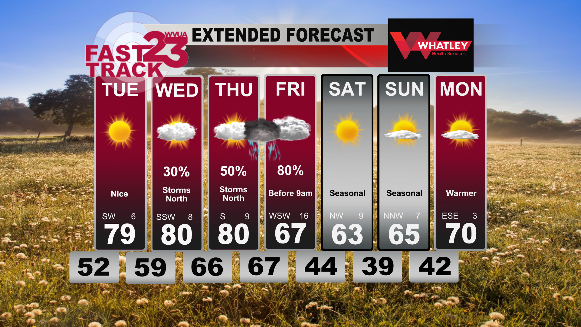
Good Tuesday afternoon! Today has been a very warm spring day, with ample sunshine. Most areas warmed into the upper 70s to near 80 today. Skies will become mostly cloudy overnight, with a low in the upper 50s to near 60.

Clouds increase on Wednesday, with a few isolated storms during the afternoon. The best chance of storms will occur north of I-20, where a few storms could become intense and produce hail. The severe weather risk is low at this time, but we’ll watch trends. Thursday will be similar, with a good chance of storms over far north Alabama, while central and south Alabama remains mostly dry. Temperatures will approach 80 on Wednesday and Thursday.

Storms will quickly pass through the area very late Thursday night or very early on Friday. Some storms could become severe and produce damaging winds. Widespread severe weather is unlikely, but make sure you have a way to receive warnings. Damaging winds will be the main risk, but an isolated tornado or two can’t be ruled out.

Join us live on WVUA23 weekdays at 5, 6 and 10:00 P.M. and weekends at 10PM for the very latest on your news, weather and sports.

Richard Scott
WVUA Chief Meteorologist
rscott@wvua23.com
Twitter: RichardWVUA23
Facebook: WVUA23RichardScott
Youtube: https://www.youtube.com/c/RichardScottWeather

Warm Weather Continues… Severe Storms Ahead… Monday PM Forecast Update

Good Monday afternoon! It has been a windy day, with winds gusting over 30mph at times. Winds will gradually calm tonight, with an overnight low in the lower 50s.

Skies will remain sunny on Tuesday, with an afternoon high in the upper 70s to near 80. A light southwest breeze will develop during the day.

Clouds increase on Wednesday, with a few isolated storms during the afternoon. The best chance of storms will occur north of I-20, where a few storms could become intense and produce hail. The severe weather risk is low at this time, but we’ll watch trends.

Join us live on WVUA23 weekdays at 5, 6 and 10:00 P.M. and weekends at 10PM for the very latest on your news, weather and sports.

Richard Scott
WVUA Chief Meteorologist
rscott@wvua23.com
Twitter: RichardWVUA23
Facebook: WVUA23RichardScott
Youtube: https://www.youtube.com/c/RichardScottWeather

Warm Start To The Week… Severe Storms Possible Thursday… Back To Average Next Weekend… Sunday PM Forecast Update… #ALwx @wvua23

Good Sunday afternoon! Warmer weather continues to plaster our temperature map. Highs today were in the mid to upper 70s once again for another well above average day. Partly cloudy skies reigned today, allowing that sunshine to peak through and warm us up. Overnight tonight, clouds stick around, keeping us a bit warm into the overnight hours. Low temperatures tonight will struggle to get below the low 60s. Tomorrow is looking a bit cloudier to wake up to where clouds become more persistent towards midday. A few isolated showers are possible around the lunchtime hour, so if you plan to go grab some lunch midday tomorrow, make sure to bring an umbrella or a rain jacket. Those showers should move out of the area by the late afternoon with mostly sunny skies returning just before sunset. Accompanied with these conditions, there is a threat for some strong and gusty winds. A wind advisory is in effect for the entire WVUA23 viewing area from 6 AM Monday morning until 6 PM Monday evening. Winds will be sustained out of the south to southwest at around 15 to 20 miles per hour, with gusts as high as around 35 mph. These winds should die down overnight after the clouds have cleared.

Waking up Tuesday morning, lower temperatures, accompanied by lower humidity will be present, making for a lovely Tuesday. We will warm up Tuesday afternoon into the mid to upper 70s, but without the humidity, it will feel much nicer. Sunshine will be abundant by the afternoon with sunny skies in the forecast. Overnight Tuesday into Wednesday, temperatures drop into the upper 50s for morning time lows. Wednesday, the humidity returns along with increasing clouds as our next system begins to approach us from the west. High temperatures in the upper 70s to low 80s on Wednesday.


Thursday, the atmosphere is seeming to set up nicely for the threat of severe weather. The Storm Prediction Center has issued a Enhanced and a Slight Risk for all of western Alabama. Models are in agreement that the atmosphere will be primed. The chance for some strong, gusty winds, small hail, and isolated tornadoes are all on the table for this event. This event will linger into the early hours on Friday before clearing out of the region by Friday afternoon. Friday, a Slight Risk is in effect for areas east of Birmingham. These same risks are all on the table for Friday as well. It is too early to predict timing and specific impact, but we will keep a close eye on the setup and keep you updated as more information becomes available with this threat.

After the storms push out of Alabama on Friday, much nicer conditions settle in. Near average temperatures return with high temperatures in the low to mid 60s will stick around for the tail end of the week and into the weekend. Along with the nicer temperatures, the sun seems to stick around with mostly sunny skies on Saturday and Sunday.

Join us live on WVUA23 weekdays at 5, 6 and10:00 P.M. and weekend sat 10PMfor the very latest on your news, weather and sports.

Ryan Larmeu
WVUA Weekend Meteorologist
Twitter: ryanlarmeuwx
Instagram: ryanlarmeuwx
Facebook: Meteorologist Ryan Larmeu


Warm Temperatures Continue… Clouds Until Tuesday… Rain Thursday… Saturday PM Forecast Update… #ALwx @wvua23v

The story of the past week has been the warmth that has engulfed the South. This warmer-than-average temperatures were back in action today with high temperatures reaching the upper 60s in the afternoon. Tonight we will fall into the 50s with mostly cloudy skies persisting in keeping those temperatures relatively warm. Tomorrow, mostly cloudy skies will continue with a few peaks of sun not out of the question. Warm temperatures stick around with high temperatures near the 80 degree in the afternoon. Above average temperatures linger overnight Sunday and into Monday with lows struggling to make it out of the low 60s.

These unseasonably warm temperatures are looking to hang on over the next 5 days. Temperatures warm up to around 80 degrees Monday with a thick cloud deck providing some shade. Some isolated showers on Monday cannot be ruled out. These depressing clouds finally clear out by Tuesday where the sunshine dominates the day with high temperatures climbing to those upper 70s. Morning lows return to the low to mid 50s by Tuesday and Wednesday morning.

Wednesday, partly sunny skies allow for temperatures to rebound to around 80 degrees once again, with an increasing chance for some evening showers. This introduces our next rainmaker with the main system moving through Thursday. Thursday, temperatures remain in the 70s with rain and thunderstorms moving through the area. The pesky rain sticks around for Friday, with cooler temperatures in the 60s. Mostly sunny skies allow for a nicer start to next weekend with temperatures in the upper 50s and low 60s by the afternoon.

Join us live on WVUA23 weekdays at 5, 6 and10:00 P.M. and weekend sat 10PMfor the very latest on your news, weather and sports.

Ryan Larmeu
WVUA Weekend Meteorologist
Twitter: ryanlarmeuwx
Instagram: ryanlarmeuwx
Facebook: Meteorologist Ryan Larmeu

Warm Weekend Ahead… Few Showers Possible… Friday PM Forecast Update #alwx @wvua23

Good Friday afternoon! Our local weather has been all over the board today, with chilly weather north of I-20 and warm weather south of I-20. A surface front has stalled near I-20 and will remain nearby through midnight. Early on Saturday, the front will lift northward as a warm front, with temperatures rising into the 70s.

A few showers will remain possible over the weekend. A widespread all day rain is not expected this weekend. Highs in the lower 70s on Saturday and nearing 80 degrees on Sunday.

A few storms will pass through on Monday, with a weak surface front. Severe weather is not expected at this time.

Join us live on WVUA23 weekdays at 5, 6 and 10:00 P.M. and weekends at 10PM for the very latest on your news, weather and sports.

Richard Scott
WVUA Chief Meteorologist
rscott@wvua23.com
Twitter: RichardWVUA23
Facebook: WVUA23RichardScott
Youtube: https://www.youtube.com/c/RichardScottWeather

Few Showers Friday… Warm Weekend Ahead.. Thursday PM Forecast Update #alwx @wvua23

Good Thursday afternoon! Our local weather was very warm this afternoon! Many areas warmed into the lower or middle 80s this afternoon. A few spotty showers continue on radar, but most areas are rain-free.

We can expect a weak surface front to drift into northern Alabama on Friday. North of the front, areas could be in the 50s all day, with 70s to the south. Right now, it appears the front will hang up near I-20, which will make for a very challenging forecast high.

Warmer weather will take over area-wide on Saturday and Sunday. Temperatures will rise into the upper 70s on Saturday and nearing 80 on Sunday.

Join us live on WVUA23 weekdays at 5, 6 and 10:00 P.M. and weekends at 10PM for the very latest on your news, weather and sports.

Richard Scott
WVUA Chief Meteorologist
rscott@wvua23.com
Twitter: RichardWVUA23
Facebook: WVUA23RichardScott
Youtube: https://www.youtube.com/c/RichardScottWeather

Very Warm Thursday… Tricky Friday Forecast… Wednesday PM Update #alwx @wvua23

Good Wednesday afternoon! Our local weather has been very warm today, breaking the record for many communities across Alabama. Temperatures reached the lower to middle 80s today. We will drop into the upper 60s tonight, under a mostly cloudy sky. A stray shower can’t be ruled out overnight.

The risk of rain on Thursday is low, but a passing rain shower can’t be ruled out on Thursday. Temperatures will warm into the middle 80s on Thursday, which is well above average for this time of the year. We can expect a weak surface front to drift into northern Alabama on Friday. North of the front, areas could be in the 50s all day, with 70s to the south. Right now, it appears the front will hang up near I-20, which will make for a very challenging forecast high.

Warmer weather will take over area-wide on Saturday and Sunday.

Join us live on WVUA23 weekdays at 5, 6 and 10:00 P.M. and weekends at 10PM for the very latest on your news, weather and sports.

Richard Scott
WVUA Chief Meteorologist
rscott@wvua23.com
Twitter: RichardWVUA23
Facebook: WVUA23RichardScott
Youtube: https://www.youtube.com/c/RichardScottWeather

Record Warmth Likely…Periods of Showers…Tricky Friday Forecast #alwx @wvua23

Tuesday was quite warm and muggy across the area with temps topping out in the upper 70s with noticeable higher humidity. That early summer-like air sticks around through your Wednesday and Thursday with highs in the middle 80s expected both days. Our record high on Wednesday is 83 (2018) and Thursday’s record high is also 83 (2012). Seemingly, 2023 will be added to the record books on both days as we are all too familiar with late February warm spells in recent years. Thankfully, no severe weather will occur from this through the weekend. Although we avoid any bad weather, this warm/humid airmass will bring spotty showers and mostly cloudy skies which will be stubborn to leave most of the week.

Friday is a tricky forecast. A cold front nears the area from our north, bringing a quick drop in temperatures to our northern and central counties. However, there is disagreement on how far south the cold front can make it. In Tuscaloosa, we are forecasting an overnight low of 66 Thursday night which becomes our afternoon high on Friday as temperatures slowly drop through the day. Meanwhile, northern counties should remain cooler than Tuscaloosa and areas south of town will remain warmer than this. Keep an eye to the forecast on Friday as things could change as we move closer to time.

Regarding the weekend and early next week, whatever coolness that does seep south will quickly retreat north as temperatures jump back into the 70s for Saturday with mostly cloudy skies and an isolated shower chance. By Sunday, our next storm system starts to near the region so the clouds and spotty shower chance carries on through our Monday. This is when rain chances increase with windy conditions and storms possible on Monday before we finally clear out on Tuesday. Temperatures will drop some with a big return to plentiful sunshine and lower humidity.

Jacob Woods

WVUA Meteorologist

Twitter: jacobwoodswx

Very Warm Days Ahead… Monday PM Forecast Update #alwx @wvua23

Good Monday afternoon! Our local weather has been warmer today, with many areas reaching into the lower 70s. Clouds have returned this evening, and we can expect a few scattered showers overnight. Temperatures will remain warm, with a low in the lower 60s. The best chance of a few showers will remain with us between midnight tonight and 10am Tuesday morning.

Temperatures will rise into the middle 70s on Tuesday, followed by middle 80s on Wednesday and perhaps upper 80s on Thursday. This will be likely record-breaking highs, which is highly unusual for late February.

We’ll remain mostly dry for Wednesday and Thursday. Daytime highs will remain in the 80s, with lows in the 60s. Friday will be a tough day to forecast, as temperatures could drop into the 50s north of I-20 on Friday, while south Alabama remains near 80. The front will lift northward again over the weekend, allowing for a warming-trend.

Join us live on WVUA23 weekdays at 5, 6 and 10:00 P.M. and weekends at 10PM for the very latest on your news, weather and sports.

Richard Scott
WVUA Chief Meteorologist
rscott@wvua23.com
Twitter: RichardWVUA23
Facebook: WVUA23RichardScott
Youtube: https://www.youtube.com/c/RichardScottWeather

Record Heat Mid Week…A Few Showers Possible…#alwx @wvua23

Good Sunday evening! We are into our warming trend, with highs today reaching the mid 60s for most places, but that won’t be close to what is in store for us later on in the week! For the remainder of this evening, expect temperatures to drop into the 50s and then eventually the 40s for lows tomorrow morning. High clouds will continue to stream across the area from the west. Tomorrow, President’s Day, we will see those temperatures go up a bit, with low to mid 70s. Clouds will still be around, and there could be a stray shower mainly after dark.

On Tuesday, we will see a weak frontal boundary settle into the area, which will serve as the focus for some scattered showers. There is still some small uncertainty on where the front actually sets up, which would determine who gets the “best” rain chances. “Best” would still be on the lower end of things (30-40%). Temperatures on Tuesday will rise into the mid 70s.

Record heat will build into the area Wednesday and Thursday, as a very strong subtropical ridge sets up. The record high for Tuscaloosa on Wednesday and Thursday is 83 degrees. With the current forecasted highs, the Thursday record has the best chance of being broken. A few showers will be possible Wednesday and Thursday.

Another cold front looks to drape across the state on Friday, and once again, depending on where that actually sets up will determine the highs and lows. Right now, we appear to be right on the edge, so we will forecast lower 70s for now, but that could easily go up or down several degrees in later forecasts. Next weekend does appear to be warmer with mid and upper 70s once again.

Join us live on WVUA23 weekdays at 5, 6 and 10:00 P.M. and weekends at 10PM for the very latest on your news, weather and sports.

Taylor Plott
WVUA Meteorologist
tplott@wvua23.com
Twitter: tplottwx
Facebook: Meteorologist Taylor Plott