Warming Trend Starts Sunday…Record Warmth Possible…Showers Midweek… #alwx @wvua23

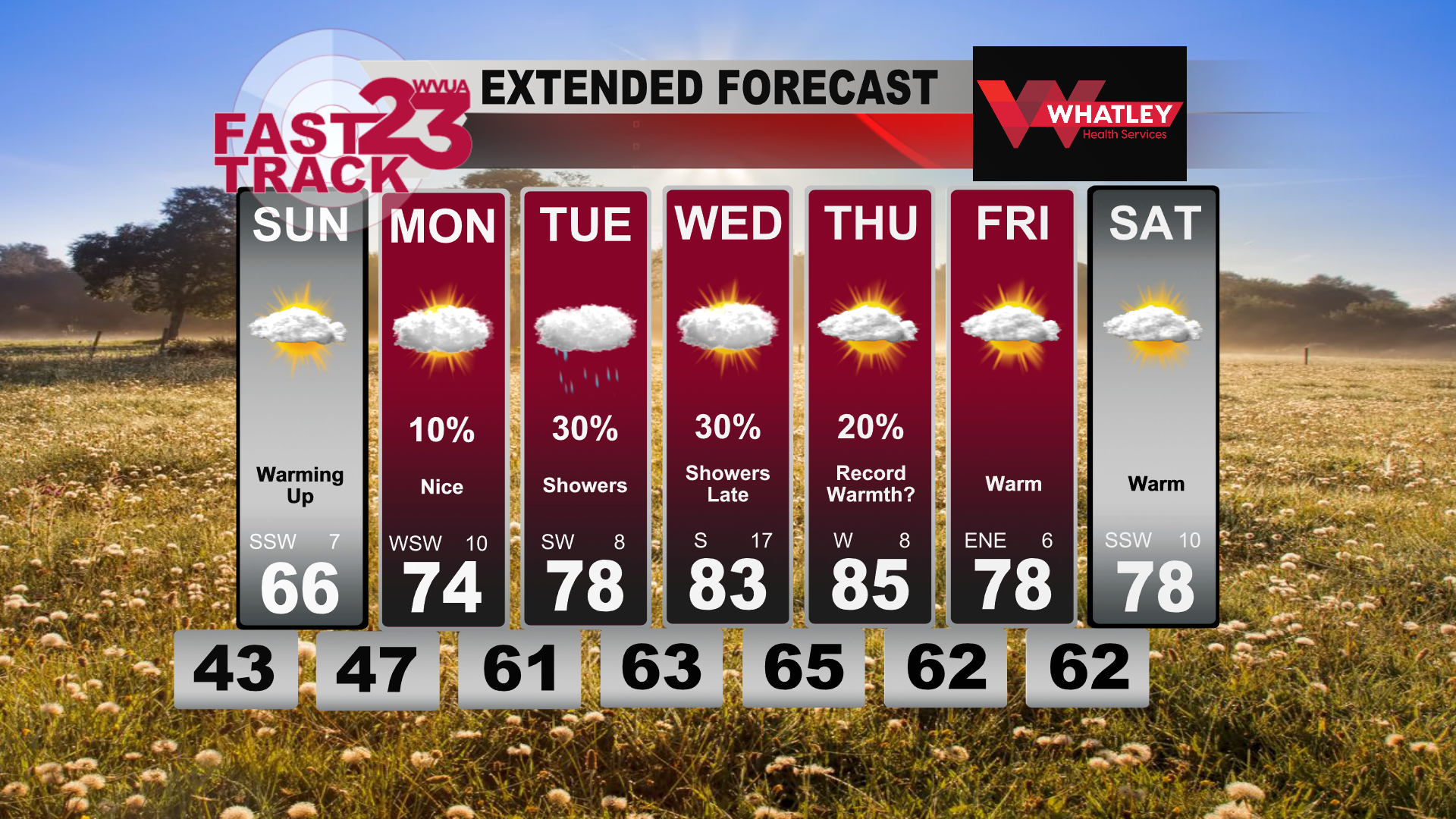
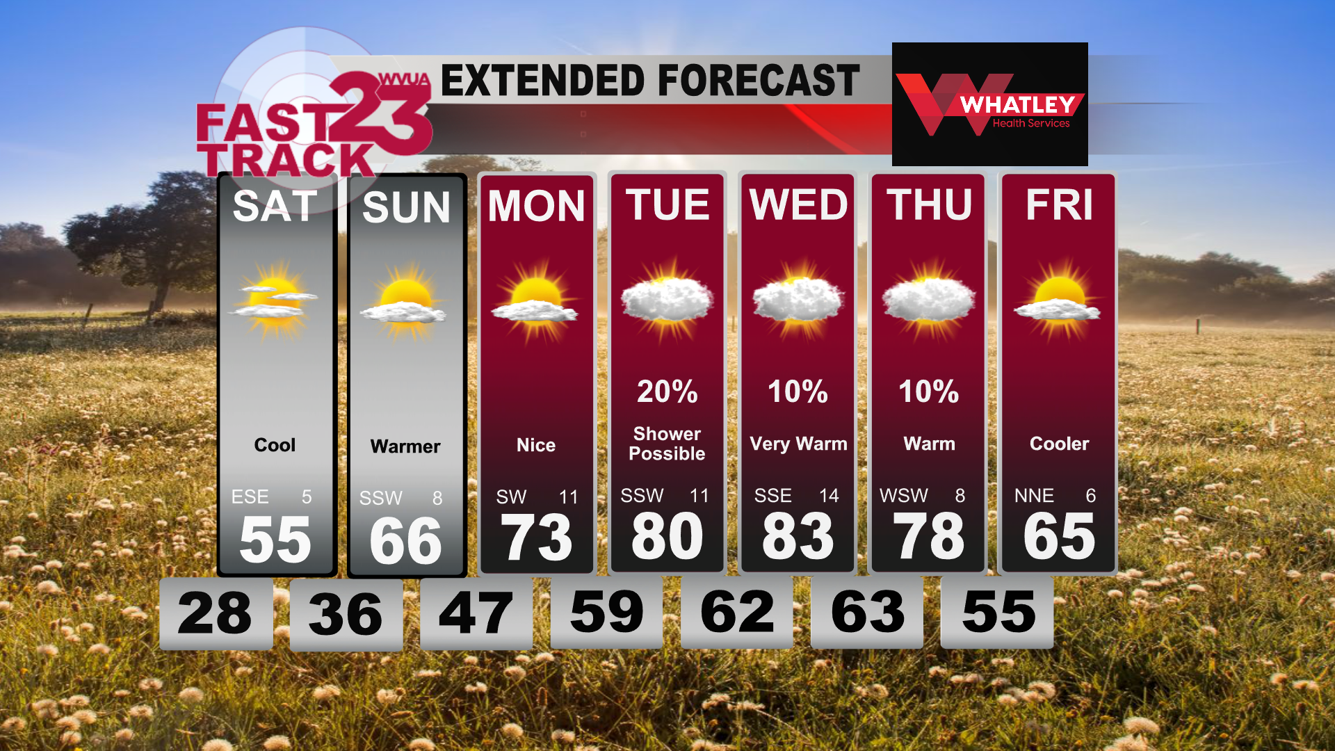
We begin our week on a nice note with dry conditions through Monday and above-average temperatures. This unseasonable warmth will last with us through the entire week with some rain chances mixed in. Sunday is when we start our warming trend with highs in the mid 60s before we reach the 70s by Monday, so take advantage of the nice weather before the thicker clouds and showers arrive midweek. These showers will be associated with a stationary boundary that sets up shop just to our north.

Tuesday is when some of us can expect scattered showers and a noticeable increase in cloud cover as that front nears central Alabama, however temperatures still remain quite warm for late February. In fact, all of us should see our first 80s of the year by Wednesday with very breezy conditions as winds stream in from the south at around 15-20 mph. Most of Wednesday will remain dry, but there is the potential for additional scattered showers and possibly storms arriving late Wednesday night. For now, we do not expect any severe weather.

Record warmth will become the main story midweek for both Wednesday and Thursday as highs reach the middle 80s under partly to mostly cloudy skies. Tuscaloosa’s record high for both of those days is 83, which seems to be in jeopardy. As we head into the weekend, skies begin to clear some as temps remain well above average in the upper 70s with dry conditions expected.

Join us live on WVUA23 weekdays at 5, 6 and 10:00 P.M. and weekends at 10PM for the very latest on your news, weather and sports.

Jacob Woods
WVUA Meteorologist
Twitter: jacobwoodswx

Cold and Dry Tonight…Warmer Weather Coming In… #alwx @wvua23

Happy Friday afternoon! After a rainy and stormy day yesterday, we are dry and chill this evening and tonight. Winds will continue to be on the breezy side this evening but will begin to decrease later tonight. Temperatures will drop into the mid and upper 20s for lows Saturday morning. The day on Saturday won’t be bad at all! It will be on the cooler side, with highs in the mid 50s, but the sunshine will make it feel a bit better. Sunday will feature warmer weather, with highs in the mid and upper 60s with a few more clouds.

Next week, it will feel like Mother Nature turned a couple of pages on the calendar! Instead of late February, we’ll be going straight to April and May! Highs will start off in the mid 70s Monday, but by Wednesday, we will be in the low to mid 80s thanks to a stout subtropical ridge in place! There will be clouds around, and a few showers possible, but for now, rain chances look to be on the lower end of things. On top of that, there doesn’t appear to be any strong to severe storm threat as of now which is nice to see!

Towards the end of the week, there should be a weak stalled out boundary nearby, so the forecast becomes a bit more uncertain, however, some slightly cooler weather could come back in briefly before next weekend.

Join us live on WVUA23 weekdays at 5, 6 and 10:00 P.M. and weekends at 10PM for the very latest on your news, weather and sports.

Taylor Plott
WVUA Meteorologist
tplott@wvua23.com
Twitter: tplottwx
Facebook: Meteorologist Taylor Plott

Flood Advisory for Fayette, Lamar, Pickens, Tuscaloosa, Walker, and Winston counties until 9pm.. @wvua23 #alwx

FLOOD ADVISORY IN EFFECT UNTIL 9 PM CST THIS EVENING...

* WHAT...FLOODING CAUSED BY EXCESSIVE RAINFALL IS EXPECTED.

* WHERE...A PORTION OF CENTRAL ALABAMA, INCLUDING THE FOLLOWING 
  COUNTIES, FAYETTE, LAMAR, PICKENS, TUSCALOOSA, WALKER AND WINSTON.

* WHEN...UNTIL 900 PM CST.

* IMPACTS...MINOR FLOODING IN LOW-LYING AND POOR DRAINAGE AREAS. 

* ADDITIONAL DETAILS...
  - AT 649 PM CST, DOPPLER RADAR INDICATED HEAVY RAIN DUE TO
    THUNDERSTORMS. MINOR FLOODING IS ONGOING OR EXPECTED TO BEGIN
    SHORTLY IN THE ADVISORY AREA. BETWEEN 1 AND 2 INCHES OF RAIN
    HAVE FALLEN.
  - ADDITIONAL RAINFALL AMOUNTS UP TO 1 INCH ARE EXPECTED OVER
    THE AREA. THIS ADDITIONAL RAIN WILL RESULT IN MINOR FLOODING.
  - SOME LOCATIONS THAT WILL EXPERIENCE FLOODING INCLUDE...
    JASPER, FAYETTE, CORDOVA, CARBON HILL, GORDO, REFORM,
    MILLPORT, CARROLLTON, ARLEY, BERRY, PARRISH, OAKMAN, ADDISON,
    KENNEDY, SIPSEY, KANSAS, NAUVOO, BELK, ELDRIDGE AND BANKSTON.

Tornado watch continues for West and Central AL until 8pm.. The Watch for Marion county has been suspended.. @wvua23 #alwx

TORNADO WATCH 40 REMAINS VALID UNTIL 8 PM CST THIS EVENING FOR
THE FOLLOWING AREAS

IN ALABAMA THIS WATCH INCLUDES 19 COUNTIES

IN CENTRAL ALABAMA

AUTAUGA               BIBB                  BLOUNT               
CHILTON               DALLAS                FAYETTE              
GREENE                HALE                  JEFFERSON            
LAMAR                 MARENGO               PERRY                
PICKENS               SHELBY                ST. CLAIR            
SUMTER                TUSCALOOSA            WALKER               
WINSTON               

THIS INCLUDES THE CITIES OF ALABASTER, ALICEVILLE, BIRMINGHAM, 
BRENT, CARROLLTON, CENTREVILLE, CLANTON, COLUMBIANA, DEMOPOLIS, 
EUTAW, FAYETTE, GREENSBORO, HALEYVILLE, HOOVER, JASPER, LINDEN, 
LIVINGSTON, MARION, MOODY, MOUNDVILLE, ONEONTA, PELHAM, 
PELL CITY, PRATTVILLE, SELMA, SULLIGENT, TUSCALOOSA, UNIONTOWN, 
VERNON, AND YORK.

Severe Thunderstorm Warning issued for Cullman County.. Strong wind and Hail expected.. @wvua23 #alwx

Rain and Storms Ending Overnight… Cooler on Friday… Thursday PM Forecast Update #alwx @wvua23

Good Thursday evening! So far, conditions have remained fairly quiet locally, with no warnings as of 5pm. We will watch radar trends carefully over the next few hours, but the severe weather risk is a bit lower compared to earlier today.

Cooler and drier air will move in on Friday and Friday night. Expect a high in the lower 50s on Friday, with a low in the upper 20s Friday night.

Skies will remain sunny on Saturday and Sunday, with a slow warming trend late in the weekend. Highs will reach the upper 50s on Saturday and middle 60s on Sunday.

Next week will feature very warm weather!

Join us live on WVUA23 weekdays at 5, 6 and 10:00 P.M. and weekends at 10PM for the very latest on your news, weather and sports.

Richard Scott
WVUA Chief Meteorologist
rscott@wvua23.com
Twitter: RichardWVUA23
Facebook: WVUA23RichardScott
Youtube: https://www.youtube.com/c/RichardScottWeather

20 counties included in the Tornado Watch for West and Central AL until 8pm.. @wvua23 #alwx

THE NATIONAL WEATHER SERVICE HAS ISSUED TORNADO WATCH 40 IN
EFFECT UNTIL 8 PM CST THIS EVENING FOR THE FOLLOWING AREAS

IN ALABAMA THIS WATCH INCLUDES 20 COUNTIES

IN CENTRAL ALABAMA

AUTAUGA               BIBB                  BLOUNT               
CHILTON               DALLAS                FAYETTE              
GREENE                HALE                  JEFFERSON            
LAMAR                 MARENGO               MARION               
PERRY                 PICKENS               SHELBY               
ST. CLAIR             SUMTER                TUSCALOOSA           
WALKER                WINSTON               

THIS INCLUDES THE CITIES OF ALABASTER, ALICEVILLE, BIRMINGHAM, 
BRENT, CARROLLTON, CENTREVILLE, CLANTON, COLUMBIANA, DEMOPOLIS, 
EUTAW, FAYETTE, GREENSBORO, HALEYVILLE, HAMILTON, HOOVER, JASPER,
LINDEN, LIVINGSTON, MARION, MOODY, MOUNDVILLE, ONEONTA, PELHAM, 
PELL CITY, PRATTVILLE, SELMA, SULLIGENT, TUSCALOOSA, UNIONTOWN, 
VERNON, AND YORK.

Tornado Watch has been issued for West and Central Alabama until 8pm.. @wvua23 #alwx

Latest Update from the NWS regarding this Afternoon’s Severe WX potential.. @wvua23 #alwx

THE TORNADO THREAT WILL LIKELY INCREASE THROUGH THE

AFTERNOON INTO THIS EVENING WITH SUPERCELLS MOVING OUT OF EASTERN

MS. A NEW TORNADO WATCH WILL LIKELY BE NEEDED BY 20Z.


DISCUSSION...AS OF 1910 UTC, REGIONAL RADAR IMAGERY SHOWED SCATTERED

THUNDERSTORMS ONGOING ACROSS PORTIONS OF CENTRAL AND SOUTHEASTERN

MS, INTO PORTIONS OF WESTERN AL. ADDITIONAL WARM-SECTOR STORMS WERE

FORMING ALONG THE MS/AL BORDER REGION. GRADUAL INTENSIFICATION IN

LIGHTNING HAS BEEN NOTED OVER THE PAST COUPLE OF HOURS, SUGGESTING A

SLOW INCREASE IN SEVERE POTENTIAL. WHILE STORMS HAVE BEEN SLOW TO

ORGANIZE THUS FAR, PERSISTENT MID-LEVEL MESOCYCLONES WITHIN A MOIST,

UNSTABLE AND STRONGLY SHEARED ENVIRONMENT (100-200 M2/S2 0-1KM SRH)

CONTINUE TO SUGGEST THE POSSIBILITY OF TORNADOES WITH SUPERCELL

STRUCTURES. DAMAGING WIND GUSTS MAY ALSO BECOME A THREAT GIVEN THE

CLUSTERED NATURE OF THE CURRENT STORMS. WITH THE POTENTIAL FOR

SUPERCELLS TO PERSIST, AND ADDITIONAL STORMS TO DEVELOP, WITHIN THE

STRONGLY SHEARED WARM SECTOR, A NEW TORNADO WATCH WILL BE NEEDED

ACROSS PARTS OF AL THIS AFTERNOON.

Strong to Severe Storms on Thursday… Dry Weekend… Wednesday PM Forecast Update #alwx @wvua23

Good Wednesday afternoon! Our local weather started off gloomy this morning, with a few areas of showers. Skies remain mostly cloudy for most of our area, but most showers have ended.

Temperatures will fall into the lower 60s tonight, then rise into the middle 70s on Thursday.

A storm system will pass through the area Thursday afternoon and early evening, with abundant instability and fair wind shear. The Storm Prediction Center has upgraded our area to an enhanced risk (level 3 of 5).

What time: The severe window begins around 12pm for west Alabama, ending by 7pm for areas west of I-65. East of I-65, your window is 4pm til 9pm.

What type: Storms could produce tornadoes, large hail and damaging winds. The higher tornado probability will be over west Alabama, but all of Alabama is in a risk.

As a reminder, we go on TV at WVUA23 non-stop during a tornado warning. We also stream non-stop on Facebook live too, search WVUA23. This is a good time to go over your severe weather safety plan and be ready to take action if needed.

Join us live on WVUA23 weekdays at 5, 6 and 10:00 P.M. and weekends at 10PM for the very latest on your news, weather and sports.

Twitter: RichardWVUA23

Facebook: RichardScottWVUA23

Weather blog:wvua23.com, click weather, select weather blog

Youtube:https://www.youtube.com/c/RichardScottWeather