Record Warmth Likely…Periods of Showers…Tricky Friday Forecast #alwx @wvua23
February 21, 2023 1 Comment

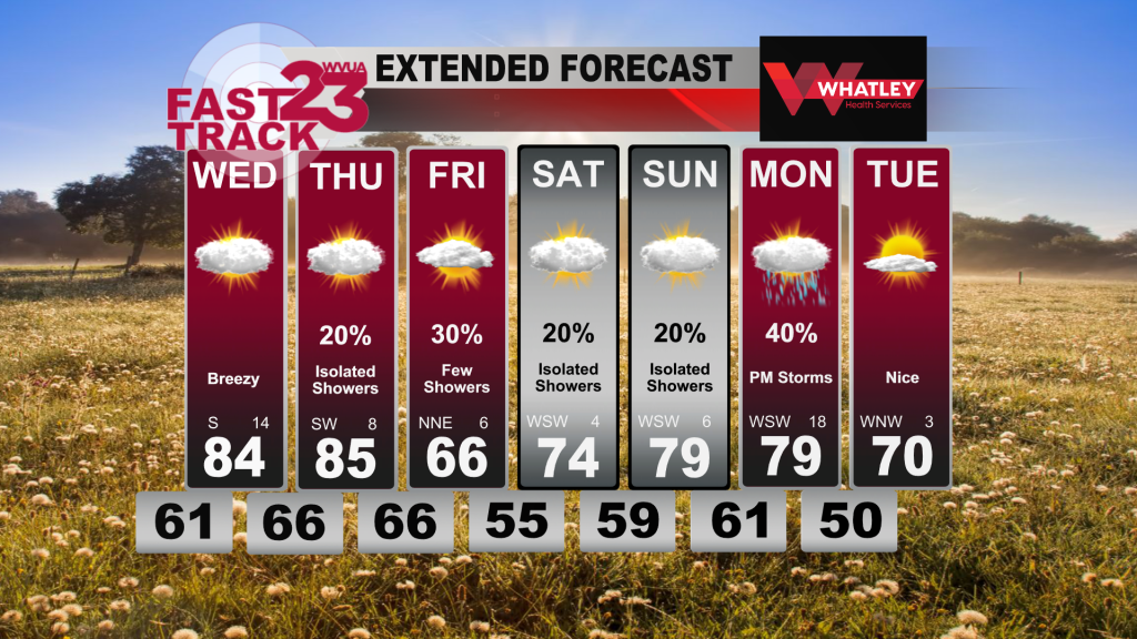
Tuesday was quite warm and muggy across the area with temps topping out in the upper 70s with noticeable higher humidity. That early summer-like air sticks around through your Wednesday and Thursday with highs in the middle 80s expected both days. Our record high on Wednesday is 83 (2018) and Thursday’s record high is also 83 (2012). Seemingly, 2023 will be added to the record books on both days as we are all too familiar with late February warm spells in recent years. Thankfully, no severe weather will occur from this through the weekend. Although we avoid any bad weather, this warm/humid airmass will bring spotty showers and mostly cloudy skies which will be stubborn to leave most of the week.
Friday is a tricky forecast. A cold front nears the area from our north, bringing a quick drop in temperatures to our northern and central counties. However, there is disagreement on how far south the cold front can make it. In Tuscaloosa, we are forecasting an overnight low of 66 Thursday night which becomes our afternoon high on Friday as temperatures slowly drop through the day. Meanwhile, northern counties should remain cooler than Tuscaloosa and areas south of town will remain warmer than this. Keep an eye to the forecast on Friday as things could change as we move closer to time.
Regarding the weekend and early next week, whatever coolness that does seep south will quickly retreat north as temperatures jump back into the 70s for Saturday with mostly cloudy skies and an isolated shower chance. By Sunday, our next storm system starts to near the region so the clouds and spotty shower chance carries on through our Monday. This is when rain chances increase with windy conditions and storms possible on Monday before we finally clear out on Tuesday. Temperatures will drop some with a big return to plentiful sunshine and lower humidity.
Jacob Woods
WVUA Meteorologist
Twitter: jacobwoodswx

