Sunny Skies Through Tuesday… Rain Returns Wednesday Evening… Warming Trend To Start The Week… Saturday PM Forecast Update… #ALwx @wvua23
February 4, 2023 1 Comment
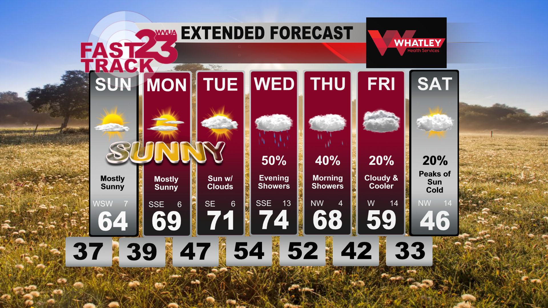
Good Saturday evening! Mostly cloudy skies settled in over Tuscaloosa today with a few peaks of sun in the afternoon hours. Temperatures today climbed into the upper 50s and lower 60s for most of Western Alabama making for a wonderful feeling day outside. This morning we started off below freezing and downright cold. Overnight tonight we will see these mostly cloudy skies begin to clear out, allowing for us to cool off into the mid to upper 30s overnight tonight and into your Sunday morning. Sunday temperatures will quickly rebound, reaching the low 60s by early afternoon, topping out in the mid 60s before the sun sets.
Starting your work week, temperatures Monday morning will be in those upper 30s and lower 40s with mostly sunny skies. These mostly sunny skies hang on all Monday making for another beautiful day. Monday night and into Tuesday, clouds begin to increase once again with temperatures only dropping into the upper 40s Tuesday morning. Tuesday we will manage to warm up into the low 70s by the afternoon.
Wednesday, our next rain maker moves into the picture with temperatures reaching the mid 70s before the rain moves in. This rain is looking to be a late evening, to overnight system that will begin after dinnertime on Wednesday. These rain showers last throughout the night and into Thursday morning. Chane of rain for Wednesday is near 50%. Thursday afternoon we dry out with temperatures reaching the upper 60s.
Friday, temperatures drop into the upper 50s for afternoon highs and we begin to see another cool down. Next Saturday is looking colder starting off in the low 30s and only reach the mid 40s by the afternoon.
Join us live on WVUA23 weekdays at 5, 6 and10:00 P.M. and weekend sat 10PMfor the very latest on your news, weather and sports.
Ryan Larmeu
WVUA Weekend Meteorologist
Twitter: ryanlarmeuwx
Instagram: ryanlarmeuwx
Facebook: Meteorologist Ryan Larmeu


